2007年VOA标准英语-Forecasters Predict Higher Number of Atlantic H
搜索关注在线英语听力室公众号:tingroom,领取免费英语资料大礼包。
(单词翻译)
By David McAlaryWashington
22 May 2007
U.S. government weather forecasters are predicting more Atlantic Ocean hurricanes this year than normal. They say last year's relatively1 calm hurricane season should not lull2 anyone into thinking that the upsurge in hurricane activity that began in the mid-1990s is over. VOA's David McAlary reports from Washington.
An average season brings six Atlantic hurricanes, with two of them major. But the U.S. oceans and atmosphere agency NOAA says there is a 75 percent chance of 10 hurricanes through November, with three to five major ones.
NOAA's lead hurricane forecaster, Gerry Bell, says it is part of a periodic increase in hurricane activity.
"We are in an active hurricane era that started in 1995," said Bell. "While we can't say for sure how long this era will last, historically other active eras have lasted 25 to 40 years."
 |
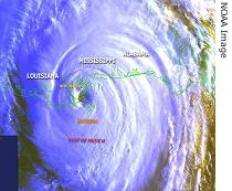
| Hurricane Katrina makes landfall |
"Seasons with similar levels of activity have historically had two to four land-falling U.S. hurricanes and generally two to three hurricanes in the region around the Caribbean Sea," he said.
"However, it is important to note that it is currently not possible to confidently predict at these extended ranges the exact number or intensity5 of land-falling hurricanes or whether a given locality will be impacted this season," Bell continued.
More frequent hurricanes were also expected last year, but the predictions went awry6 when a global weather pattern called El Nino interfered7 in August and September, the peak of the season. An El Nino weakens trade winds in the lower atmosphere that move hurricanes and strengthens the jet stream in the upper atmosphere that shears8 their tops off.
Bell says there is a strong likelihood that another weather pattern, called La Nina, will develop in one to three months with the opposite effect.
"Unfortunately the combination of La Nina and an active hurricane era is known to produce very active hurricane seasons," he said. "Now, even if La Nina doesn't develop, the conditions associated with this ongoing9 active hurricane era still favor an above normal season."
The advent10 of a La Nina would also have other global weather impacts opposite those of an El Nino. While El Ninos warm the waters of the equatorial Pacific, La Ninas cool them.
NOAA climate expert Edward O'Lenic says the cooler sea surface affects the atmosphere so that regions accustomed to certain types of weather such as rain or drought experience them more intensely.
"One simple way to get a handle on [understand] the impacts of La Nina and El Nino is to think of them as the opposite sides of the same coin," he said. "Where La Nina tends to make places that are normally wet, wetter and places that are normally dry, drier, El Nino does the opposite of that in those locations."
In addition to intensifying11 Atlantic hurricane activity, La Ninas usually cause increased rainfall across Indonesia and northern Australia, the Amazon Basin, southeastern Africa, Scandinavia, and the U.S. Great Lakes region and Pacific northwest.
In contrast, below average rainfall normally occurs across the eastern half of the Pacific at the equator, eastern equatorial Africa, Japan and Korea, the southern United States and northern Mexico.
 收听单词发音


